Hiking trails
All trails are marked. Times are always without breaks and are from "Schweizer Wanderwege" (https://www.schweizer-wanderwege.ch/). The trails have been classified as Easy Medium Strenuous ("Strenuous" for untrained hikers. This does not mean that the trails are difficult).
1) Campiroi-Audesc-Sorsello-Campiroi

Easy . The green arrow shows where the trail to Audesc starts, just after the first house of the "Monti di Co'". In Audesc you can stop to picnic at one of the two fountains.
Distance: 3.88 km
Ascent/descent: 449 m / 449 m
Altitude (Min/Max): 1234 m / 1640 m
Hiking time: 1 h 23 min
2) Campiroi-Frageira-Alpe Nara-Cassin-Audesc-Sorsello-Campiroi

Medium. The green arrow shows where the trail to Audesc starts, just after the first house of the "Monti di Co'". The yellow arrow shows the small part of the trail that gets lost in the meadows of the Alps. Just walk to the alp's huts! In summer cheese is sold there (a mixture of cheese between goat and cow). If you still feel like, you can walk to "Bassa di Nara", from where you have a beautiful view of the Blenio Valley.
Distance: 10.15 km
Ascent/descent: 868 m / 868 m
Altitude (Min/Max): 1234 m / 1935 m
Hiking time: 3 h 31 min
3) Campiroi-Gianon "Belvedere" Campiroi
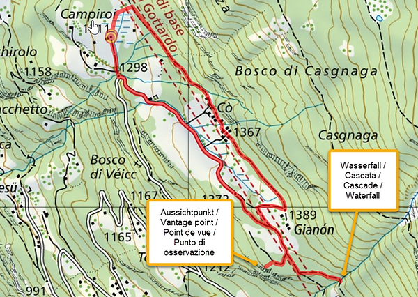
(Very) easy. Suitable for small children. Beautiful viewpoint ("Belvedere") over Calonico and possibility to bathe at the waterfall.
Distance: 2.79 km
Ascent/descent: 143 m / 143 m
Altitude (Min/Max): 1298 m / 1390 m
Hiking time: 49 min
4) Sobrio-Usc-Cascine-Puscett-Alpe Foppascia-Alpe dei Piai-Alpe Crastumo-Audesc-Sorsello-Campiroi


Strenous. Very nice views. From Campiroi to Calonico on foot then postbus from Calonico to Sobrio.
Distance: 14.5 km
Ascent/descent: 1094 m / 897 m
Altitude (Min/Max): 1129 m / 2027 m
Hiking time: 5 h 8 min
5) "Strada alta": Campiroi-Sorsello-Tengia-Rossura-Figgione-Calpiogna-Osco-(Campello)-Rossura-Tengia-Paschirolo-Campiroi


Strenous. This route (Osco-Campiroi) is part of the "Strada Alta". The yellow arrow shows a self-service store (ice cream, various drinks). In Osco there is a restaurant where you can stop for lunch. The detour via Campello on the way back can be omitted. That would save about 250 m of height difference. Some sections of the trail were part of the old mule track and are partially preserved (see under "Historical Information" and then under "The Nara pass").
Alternative for the way back: in Osco you could take the post bus to Faido/Lavorgo and then to Calonico (make sure to check the times in advance in the SBB timetable!) and then walk to Campiroi.
Distance: 17.34 km
Ascent/descent: 1150 m / 1150 m
Altitude (Min/Max): 1043 m / 1369 m
Hiking time: 6 h
6) Campiroi-Sorsello-Campiroi OR Campiroi-Sorsello-Tengia-Campiroi
(Very) easy. Suitable for young children. Possibility to bathe at the waterfall in Tengia (yellow arrow).
Sorsello:
Distance: 0.98 km
Ascent/descent: 98 m / 98 m
Altitude (Min/Max): 1239 m / 1327 m
Hiking time: 18 min

Sorsello and waterfall in Tengia
Distance: 2.68 km
Ascent/descent: 226 m / 226 m
Altitude (Min/Max): 1103 m / 1312 m
Hiking time: 54 min

7) Campiroi-Audesc-Molare-Audesc-Sorsello-Campiroi
Medium . From Molare there is the possibility to walk up to Cari (additional 150 m height difference) where there is a restaurant.
Distance: 12.79 km
Ascent/descent: 881 m / 881 m
Altitude (Min/Max): 1234 m / 1640 m
Hiking time: 4 h 11 min


8) Campiroi-Audesc-Alpe Nara-Bassa di Nara-Capanna Piandios-Cambra-Bassa di Nara-Alpe Nara-Cassin-Audesc-Sorsello-Campiroi

Strenous. Some sections of the trail were part of the old mule track and are partially preserved (see under "Historical Information" and then under "The Nara pass"). At the Piandios Refuge you can eat or alternatively you can walk to the next one (Refuge Gorda, 1 h 30 min from the Refuge Piandios). Beautiful views of the Blenio Valley!
Distance: 15.35 km
Ascent/descent: 1416 m / 1416 m
Altitude (Min/Max): 1234 m / 2123 m
Hiking time: 6 h 16 min
9) Campiroi-Bosco di Veicc (1167)-Calonico-Sacchetto-Campiroi
Easy . In Calonico you can visit the church of San Martino, a Walser house from 1684 and an old mill (see also "Nearby attractions") and buy refreshments at "Da Paolina".
Distance: 3.36 km
Ascent/descent: 358 m / 358 m
Altitude (Min/Max): 969 m / 1311 m
Hiking time: 1 h 20 min

